














































PORTAL EVANGÉLICO - NOTÍCIAS
EVANGELIC DOORWAY - NEWS
IGREJA FLUTUANTE NO RIO NEGRO (AMAZONAS)
FLOATING CHURCH IN RIO NEGRO (AMAZON)
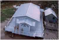
A Igreja CONGREGAÇÃO CRISTÃ DO BRASIL mantém um templo que flutua sobre as abundantes águas do Rio Negro, o maior dos afluentes da margem esquerda do Rio Amazonas (Brasil) e o mais extenso rio de água negra do mundo, e o segundo maior em volume de água — atrás somente do Amazonas, o qual ajuda a formar.
The Church CHRISTIAN CONGREGATION OF BRAZIL has a temple floating on the abundant waters of the Rio Negro, the largest left bank tributary of the Amazon River (Brazil) and the longest river of black water in the world, and the second largest volume of water - behind only Amazon, which helps to form.
Pelo que se sabe, é a única Igreja no território brasileiro com esta característica, efetivamente sobre a água e com acesso apenas de barco, e se algum visitante tenha conhecimeno da existênia de outra (s) no país, solicitamos por obséquio que nos informe, para que possamos fazer os necessários registros e publicações.
From what we know, is the only church in the Brazilian territory with this feature, actually over the water and accessible only by boat, and if a visitor has knowledge of the existence of other (s) in the country, please let us know, so we can make the necessary records and publications.
CONHEÇA O RIO NEGRO
MEET THE RIO NEGRO
O rio Negro é navegável por 720 quilômetros acima de sua foz e pode chegar a ter um mínimo de 1 metro de água em tempo de seca, mas há muitos bancos de areia e outras dificuldades menores. Na estação das chuvas, transborda, inundando as regiões ribeirinhas em distâncias que vão de 32 km até 640 km.
The Rio Negro is navigable for 720 km above its mouth and can reach a minimum of 1 meter of water in times of drought, but there are many sand banks and other minor difficulties. In the rainy season, it overflows, flooding the coastal regions at distances ranging from 32 km to 640 km.
O rio Negro é o maior afluente da margem esquerda do rio Amazonas, o mais extenso rio de água negra do mundo, e o segundo maior em volume de água — atrás somente do Amazonas, o qual ajuda a formar. Tem sua origem entre as bacias do rio Orinoco e Amazônica, e também conecta-se com o Orinoco através do canal de Casiquiare. Na Colômbia, onde tem a sua nascente, é chamado de rio Guainia. Seus principais afluentes são o Rio Branco e o rio Vaupés que disputa ser o começo do rio Orinoco junto com o rio Guaviare, drena a região leste dos Andes na Colômbia. Após passar por Manaus, une-se ao rio Solimões e a partir dessa união este último passa a chamar-se rio Amazonas.
The Rio Negro is the largest tributary of the left bank of the Amazon River, the longest river of black water in the world, and the second largest volume of water - second only to Amazon, which helps to form. Has its origin between the basins of the Orinoco and Amazon, and also connects with the Orinoco by Casiquiare channel. In Colombia, where it has its source, is called the river Guainia. Its main tributaries are the White River and the river Vaupés dispute that be the beginning of the Orinoco with the Guaviare River, drains the area east of the Andes in Colombia. After going through Manaus, joins the Solimões River and from this union is to call the Amazon River.
Todo ano, com o degelo nos Andes, e a estação das chuvas na região Amazônica, o nível do rio sobe vários metros, alcançando sua máxima entre os meses de Junho e Julho, e o pico coincide com o "verão amazônico", e portanto, o nível do rio começa a baixar até meados de novembro, quando novamente inicia o ciclo da cheia.
Every year, with a thaw in the Andes, and the rainy season in the Amazon, the river level rises several feet, reaching its maximum between the months of June and July, and the peak coincides with the "Amazon summer," and therefore the river level begins to drop until mid-November, when the cycle starts again in full.
Em Manaus, a máxima do Rio Negro vem sendo registrado a mais de cem anos, e há um quadro no Porto de Manaus com todos os registros históricos, inclusive o da maior cheia de todos os tempos ocorrido em 01 de julho de 2009, alcançando a cota máxima de 29,77 metros acima do nível do mar, valendo ressaltar que todos os rios da Bacia Amazônica sofrem o mesmo fenômeno de subidas e baixas em seus níveis, comandados pelos dois maiores rios: Rio Negro e Rio Solimões (que ao se encontrarem abaixo da cidade de Manaus, formam o Rio Amazonas).
In Manaus, the maximum of the Rio Negro has been recorded over a hundred years, and there is a picture at the Port of Manaus with all historical records, including the biggest flood of all time occurred on July 1, 2009, reaching maximum height of 29.77 meters above sea level, is worth highlighting that all the rivers of the Amazon Basin suffer the same phenomenon of rising and low in their levels, controlled by two major rivers: the Rio Negro and Rio Solimões (which meet the below the city of Manaus, forming the Amazon River).
